Yosemite Valley Trail Map


Detailed App Info:
Application Description
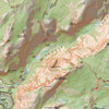
Carry the best trail map for Yosemite Valley with you on your iPhone or iPod touch! This app has the highest-quality trail and topographic information available, all stored in the app itself so you don’t need a cell signal to access it. Whether you’re hiking Half Dome or trying to identify the spectacular granite faces of the Valley, this map will help you find your way. The map shows trails, roads, vegetation, 80-foot contours, water features, peaks, campgrounds, and more, and works with the iPhone’s GPS. Scrolling and zooming are fast and smooth--you’ll never wait for this app to redraw the screen or load data.
Note: This map only covers Yosmite Valley. For complete coverage of Yosemite National Park at a larger scale, with 200-foot contours, see our Yosemite National Park Recreation Map (available May 30, 2009).
Note: This map only covers Yosmite Valley. For complete coverage of Yosemite National Park at a larger scale, with 200-foot contours, see our Yosemite National Park Recreation Map (available May 30, 2009).
Requirements
Your mobile device must have at least 15.21 MB of space to download and install Yosemite Valley Trail Map app. Yosemite Valley Trail Map was updated to a new version. Purchase this version for $4.99
If you have any problems with installation or in-app purchase, found bugs, questions, comments about this application, you can visit the official website of Earthrover Software Patrick Leger at http://www.earthrover.org/Earthrover_Software/Earthrover_Maps.html.
Copyright © Earthrover Software