MammothMap - Mammoth High Country Trail Map


Detailed App Info:
Application Description
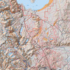
MammothMap brings the Mammoth High Country Trail Map by Tom Harrison Maps to the iPhone and iPod Touch. MammothMap covers the southern shore of Mono Lake, parts of the John Muir Wilderness and Ansel Adams Wilderness (including the Minarets), Mammoth Mountain, June Lake, Lake Mary, Lee Vining, the Mono Basin National Scenic Area, the eastern portion of Yosemite National Park, parts of Inyo National Forest and Sierra National Forest, and Devil's Postpile National Monument. The map shows trails, backcountry roads, highways, towns, water features, peaks, canyons, campgrounds, ranger stations, and more. This map is perfect for day hikes, backpacking, fishing, mountain biking, 4x4 backcountry touring, orienteering, geocaching, and just about any other way you'd want to explore this area.
Navigate the map using standard touch gestures to zoom and drag. Mark your location, measure distances, orient yourself by taking bearings to landmarks, and use your iPhone's GPS to find your location on the map. Add your own markers to the map, and export them via email for display in Google Earth or other applications. Map data is included in the application, so you don't need an internet connection to use it.
Navigate the map using standard touch gestures to zoom and drag. Mark your location, measure distances, orient yourself by taking bearings to landmarks, and use your iPhone's GPS to find your location on the map. Add your own markers to the map, and export them via email for display in Google Earth or other applications. Map data is included in the application, so you don't need an internet connection to use it.
Requirements
Your mobile device must have at least 21.64 MB of space to download and install MammothMap - Mammoth High Country Trail Map app. MammothMap - Mammoth High Country Trail Map is available on iTunes for $4.99
If you have any problems with installation or in-app purchase, found bugs, questions, comments about this application, you can visit the official website of Earthrover Software Patrick Leger at http://www.earthrover.org/Earthrover_Software/MammothMap.html.
Copyright © Earthrover Software