Geograph MA


Detailed App Info:
Application Description
The ultimate app for Geography/Geology amateurs and professionals."
- Mel Martin, TUAW.com
Do you know which state assembly district you are in? Which school district? Where is the closest railroad? Is there a mine nearby? What kind of rock are you sitting on?
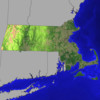
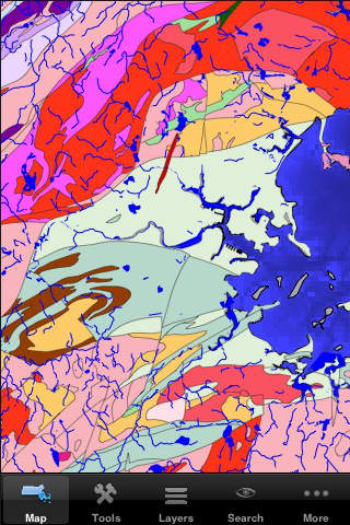
Geograph MA is the edition of the popular GIS (geographic information system) covering the commonwealth of Massachusetts. It is a self-contained application (no Internet or cellular access required) that contains a vast amount of information about the geography and geology of the Bay State. You can combine various data layers, zoom in and out, and get a lot of details about the physical and human geography of Massachusetts.
While this is a professional-grade tool, it can easily be used by anyone curious about their environment.
This release contains over 45 layers (new layers are frequently added). Installed by default are:
- states outlines
- the complete geological map from USGS
- surficial materials and faults
- terrain elevation and bathymetry
- zip codes
- over 4,600 named features (summits, tunnels, cliffs, bridges, etc...) with link to USGS information page
- U.S. congressional districts with link to representatives' web sites
- over 1,100 mineral resources with link to USGS web site
- active mines
- public land ownership
- hydrologic units
- EPA ecological regions
- USGS quadrangles
- urban areas
- counties with link to census data
- hydrology
- roads and major streets
- railroad tracks
- cities and towns with link to census data
- UTM zones
- main aquifers with link to EPA web site
Layers that can be downloaded from the application include:
- state House districts with link to representatives' web sites
- state Senate districts with link to senators' web sites
- elementary, secondary and unified school districts
- boundaries of cities and villages with link to census data
- town boundaries
- landmark areas (parks, campgrounds, airports, etc...)
- landmark points (schools, hospitals, fire stations, etc...)
- airports with link to FAA data pages for each airport
- areas of critical environmental concern with link to detail page for each site
- geodetic points with link to the National Geodetic Survey details pages
- national park boundaries with link to the National Park Service web page for each park
- waterways and ports from the U.S. Army Corps of Engineers
- railroad crossings with link to details page from the Federal Railroad Administration
- detailed surface geology for some parts of the state
- boat/fishing access
- long-distance bicycle trails
- natural communities
- FEMA flood zones (premium content)
Each layer contains additional information about its features. For instance, the geology layer has a description of the unit's name, age range, rock type, and description. Each mine has a name, a commodity, a facility type, and a company name. See our web site for more information about each layer. Layers can be re-ordered and combined with transparency, allowing an unlimited number of combinations.
- Mel Martin, TUAW.com
Do you know which state assembly district you are in? Which school district? Where is the closest railroad? Is there a mine nearby? What kind of rock are you sitting on?
Geograph MA is the edition of the popular GIS (geographic information system) covering the commonwealth of Massachusetts. It is a self-contained application (no Internet or cellular access required) that contains a vast amount of information about the geography and geology of the Bay State. You can combine various data layers, zoom in and out, and get a lot of details about the physical and human geography of Massachusetts.
While this is a professional-grade tool, it can easily be used by anyone curious about their environment.
This release contains over 45 layers (new layers are frequently added). Installed by default are:
- states outlines
- the complete geological map from USGS
- surficial materials and faults
- terrain elevation and bathymetry
- zip codes
- over 4,600 named features (summits, tunnels, cliffs, bridges, etc...) with link to USGS information page
- U.S. congressional districts with link to representatives' web sites
- over 1,100 mineral resources with link to USGS web site
- active mines
- public land ownership
- hydrologic units
- EPA ecological regions
- USGS quadrangles
- urban areas
- counties with link to census data
- hydrology
- roads and major streets
- railroad tracks
- cities and towns with link to census data
- UTM zones
- main aquifers with link to EPA web site
Layers that can be downloaded from the application include:
- state House districts with link to representatives' web sites
- state Senate districts with link to senators' web sites
- elementary, secondary and unified school districts
- boundaries of cities and villages with link to census data
- town boundaries
- landmark areas (parks, campgrounds, airports, etc...)
- landmark points (schools, hospitals, fire stations, etc...)
- airports with link to FAA data pages for each airport
- areas of critical environmental concern with link to detail page for each site
- geodetic points with link to the National Geodetic Survey details pages
- national park boundaries with link to the National Park Service web page for each park
- waterways and ports from the U.S. Army Corps of Engineers
- railroad crossings with link to details page from the Federal Railroad Administration
- detailed surface geology for some parts of the state
- boat/fishing access
- long-distance bicycle trails
- natural communities
- FEMA flood zones (premium content)
Each layer contains additional information about its features. For instance, the geology layer has a description of the unit's name, age range, rock type, and description. Each mine has a name, a commodity, a facility type, and a company name. See our web site for more information about each layer. Layers can be re-ordered and combined with transparency, allowing an unlimited number of combinations.
Requirements
Your mobile device must have at least 21.13 MB of space to download and install Geograph MA app. Geograph MA is available on iTunes for $4.99
If you have any problems with installation or in-app purchase, found bugs, questions, comments about this application, you can visit the official website of Integrity Logic Integrity Logic LLC at http://www.integrity-logic.com/GeographMA.
Copyright © 2010 Integrity Logic LLC