Geograph IL


Detailed App Info:
Application Description
The ultimate app for Geography/Geology amateurs and professionals."
- Mel Martin, TUAW.com
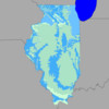
Geograph IL is the edition of the popular GIS (geographic information system) covering the state of Illinois. It is a self-contained application (no Internet or cellular access required) that contains a vast amount of information about the geography and geology of the Prairie State. Using the iPhone's GPS, it enables you to navigate the state and get a much better understanding of your surroundings, identify geological formations, mines, rivers, school districts, etc....
This release contains 30 layers, which can be combined in any desired way:
- states outlines
- the complete geological map from USGS, with link to USGS web site for each unit
- surficial materials
- terrain elevation
- bathymetry for the southern half of lake Michigan
- zip codes
- over 2,600 named features (summits, tunnels, cliffs, bridges, etc...) with link to USGS page for each feature
- glacial limits
- U.S. congressional districts with link to representatives' web sites
- almost 2,300 mineral resources with link to USGS web site for each resource
- active mines
- old faults
- public land ownership
- hydrologic units with link to data page on EPA web site
- seismic risk
- all earthquakes in recorded history of magnitude 3.0 and above
- EPA ecological regions
- USGS quadrangles
- township and range
- urban areas
- counties with link to Census data
- hydrology
- roads and major streets
- railroad tracks
- cities and towns
- potassium/argon dates
- state plane zones
- UTM zones
- main aquifers
A number of additional layers can be downloaded from the application, including:
- state House districts with link to representatives' web sites
- state Senate districts with link to senators' web sites
- elementary school districts
- secondary school districts
- unified school districts
- boundaries of cities and villages with link to Census data
- towns
- landmark areas (parks, campgrounds, airports, etc...)
- landmark points (schols, hospitals, fire stations, etc...)
- city of Chicago alderman wards with link to aldermans' web sites
- city of Chicago precincts (all 2,605 of them)
- city of Chicago neighborhoods
Each layer contains additional information about each feature. For instance, the geology layer has a description of the unit's name, age range, rock type, and description. Each mine has a name, a commodity, a facility type, and a company name. See our web site for more information about each layer.
There have been significant improvements since the release of the sister programs covering CA, TX, NY/NJ/CT, FL, WA/OR, AZ, CO, UT, NV, NM, ID, MT, WY, MN and WI. More layers now have web links. Several bugs have been fixed.
- Mel Martin, TUAW.com
Geograph IL is the edition of the popular GIS (geographic information system) covering the state of Illinois. It is a self-contained application (no Internet or cellular access required) that contains a vast amount of information about the geography and geology of the Prairie State. Using the iPhone's GPS, it enables you to navigate the state and get a much better understanding of your surroundings, identify geological formations, mines, rivers, school districts, etc....
This release contains 30 layers, which can be combined in any desired way:
- states outlines
- the complete geological map from USGS, with link to USGS web site for each unit
- surficial materials
- terrain elevation
- bathymetry for the southern half of lake Michigan
- zip codes
- over 2,600 named features (summits, tunnels, cliffs, bridges, etc...) with link to USGS page for each feature
- glacial limits
- U.S. congressional districts with link to representatives' web sites
- almost 2,300 mineral resources with link to USGS web site for each resource
- active mines
- old faults
- public land ownership
- hydrologic units with link to data page on EPA web site
- seismic risk
- all earthquakes in recorded history of magnitude 3.0 and above
- EPA ecological regions
- USGS quadrangles
- township and range
- urban areas
- counties with link to Census data
- hydrology
- roads and major streets
- railroad tracks
- cities and towns
- potassium/argon dates
- state plane zones
- UTM zones
- main aquifers
A number of additional layers can be downloaded from the application, including:
- state House districts with link to representatives' web sites
- state Senate districts with link to senators' web sites
- elementary school districts
- secondary school districts
- unified school districts
- boundaries of cities and villages with link to Census data
- towns
- landmark areas (parks, campgrounds, airports, etc...)
- landmark points (schols, hospitals, fire stations, etc...)
- city of Chicago alderman wards with link to aldermans' web sites
- city of Chicago precincts (all 2,605 of them)
- city of Chicago neighborhoods
Each layer contains additional information about each feature. For instance, the geology layer has a description of the unit's name, age range, rock type, and description. Each mine has a name, a commodity, a facility type, and a company name. See our web site for more information about each layer.
There have been significant improvements since the release of the sister programs covering CA, TX, NY/NJ/CT, FL, WA/OR, AZ, CO, UT, NV, NM, ID, MT, WY, MN and WI. More layers now have web links. Several bugs have been fixed.
Requirements
Your mobile device must have at least 36.38 MB of space to download and install Geograph IL app. Geograph IL is available on iTunes for $4.99
If you have any problems with installation or in-app purchase, found bugs, questions, comments about this application, you can visit the official website of Integrity Logic Integrity Logic LLC at http://www.integrity-logic.com/GeographIL.
Copyright © 2009 Integrity Logic LLC