Cruise Ports - WEST Zoomable Atlas


Detailed App Info:
Application Description
Our unique zoomable 'Cruise Ports - WEST' atlas covers the WESTERN Hemisphere and uses online map services to generate a series of custom real-time regional maps showing colored markers where popular cruise ports (and related destinations) are located. Also included are maps and facts for each of these ports [red & orange markers] and for related slow-cruising locations [blue markers] and nearby popular land destinations [yellow markers].
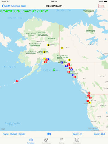
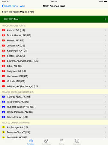
Using the "Cruise Ports" tab, select the region of general interest by tapping the desired area on the red map of the Western Hemisphere. A list of available numbered destinations in that selected region will then be displayed, as well as a button to display an overview map of the selected area showing colored markers at the locations of all of the popular destinations in that area. Tap the name of the desired destination in the list to display a detail map of that destination.
Switch between 'Road', 'Hybrid', and 'Satellite' map formats at a tap - your last preference is automatically remembered. Zoom in (or out) to display any level of map detail level desired -- down to the individual house level! Change to a different area of focus with the drag of a finger and your display is instantly updated. And your Current Location is always highlighted by an animated blue dot, if you allow the app to use your current location.
Tapping a red "Facts" Button, when shown in the upper right, retrieves extensive relevant interactive descriptive information from Wikipedia. By following indicated links, more related facts and photos are available for your selected area of interest.
GPS and Geocaching Coordinates are also displayed on all maps in three different popular formats and in different colors -- dddmmss.xx [Traditional GPS] , dddmm.xxx [Geocaching], and ddd.xxxxx [Decimal GPS]. As you drag or zoom on a map display, these coordinate displays are automatically updated.
The app also includes a "World" tab that launchs any of the component apps in our related World Atlas series that are installed on your device. These low-cost apps, when installed, provide additional maps and facts about the countries (and states) in different parts of the world that may enhance your cruising experience.
Requirements
Your mobile device must have at least 2.62 MB of space to download and install Cruise Ports - WEST Zoomable Atlas app. Cruise Ports - WEST Zoomable Atlas was updated to a new version. Purchase this version for $0.99
If you have any problems with installation or in-app purchase, found bugs, questions, comments about this application, you can visit the official website of Henry Vaughan at http://www.fldstone.com/mQ_iph.html.
Copyright © 2011-13 Henry Vaughan