Cruise Ports - Europe Zoomable Atlas


Detailed App Info:
Application Description
Our zoomable 'Cruise Ports - Europe' map atlas is a specialized product that covers popular cruise ship ports in 'Europe' (from Reykjavík in Iceland to Port Said in northern Egypt) and is available in the languages of English [the Default], Spanish, French, German, Italian, Netherlands [Dutch], Portuguese (Europe), and Portuguese (Brazil). It generates a series of custom real-time regional maps showing colored markers where popular cruise ports (and related destinations) are located. Also included are maps and facts for each of these ports [red & orange markers] and for related slow-cruising locations [blue markers] and nearby popular land destinations [yellow markers].
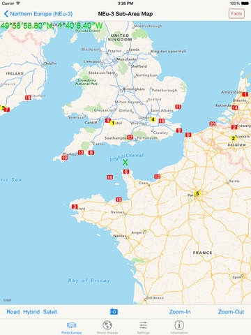
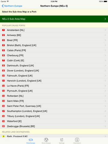
Using the 'Ports Europe' tab, select the region of general interest by tapping the desired area on the red map of 'Europe'. Choose a sub-area of interest. A list of available numbered destinations in that selected region will then be displayed, as well as a button to display an overview map of the selected area showing colored markers at the locations of all of the popular destinations in that area. Tap the name of the desired destination in the list to display a detail map of that destination.
Easily switch between 'Road', 'Hybrid', or 'Satellite' maps, and zoom in (and out) to any detail level desired -- down to the house level! Change to a different area of focus with the drag of a finger and your display is instantly updated. Your Current Location is always highlighted by an animated blue dot, if you choose to allow the app to use your current location.
Tapping a 'Facts' Button, when shown, displays extensive relevant interactive descriptive information from Wikipedia. By following indicated links, more facts and photos are available in a specific areas of interest.
Using the 'Settings' tab, you can select the GPS Coordinates format to be displayed on all maps. Three different popular display formats are supported: Traditional [dddmmss.xx] , Modern [ddd.xxxxx], and Geocaching [dddmm.xxx]. As you drag or zoom on a map display, the GPS coordinates of the center of the display are automatically updated.
Using the 'World Atlases' tab, tap an appropriate button to launch any of the other component apps in our World Atlas series that are installed on the device. Information links are also provided for our other similar apps that are not currently non-installed.
Requirements
Your mobile device must have at least 4.45 MB of space to download and install Cruise Ports - Europe Zoomable Atlas app. Cruise Ports - Europe Zoomable Atlas is available on iTunes for $0.99
If you have any problems with installation or in-app purchase, found bugs, questions, comments about this application, you can visit the official website of Henry Vaughan at http://www.fldstone.com/mQ_Support.html.
Copyright © 2012-2014 Henry Vaughan