Topo Maps


Detailed App Info:
Application Description
★ View Natural Resources Canada 1:50,000 and U.S. Geological Survey 1:24,000 topographical maps on your iPhone or iPod touch. ★ Map downloads are FREE! ★ Ideal for hiking and other outdoor activities.
U.S. users write:
❝ Very pleased - it was smooth to work with, the maps downloaded quickly, and the level of detail when zooming really close in was amazing ❞
❝ If you want to experience the joy of navigation without all the paper that goes into the typical map, here is a great app for you ❞
❝ Downloading maps is easy and fast ... Map displays beautifully and zooms flawlessly ❞
★ The first iPhone app to show NRCan topographical maps!
★ Map downloads are FREE!
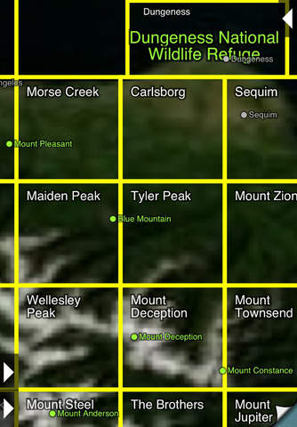
★ Locate the maps you need on the satellite view. To install a map, touch for about half a second. Touch again to view it.
★ No network connection is needed once the maps have been installed.
★ Touch the "current location" button to see where you are. Use the compass to align the map.
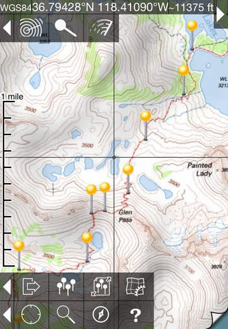
★ Search by name for over a million towns, peaks, lakes, parks and other features.
★ Mark waypoints, and import and export waypoint files in GPX, KML and CSV formats.
★ See coordinates in NAD27 or WGS84 degrees, degrees minutes and seconds, UTM, or MGRS formats.
★ Measure distances (miles, feet and km) and bearings (true and magnetic).
★ Links to the Panoramascope, another app by the same author, that computes the view from the selected location.
Coverage: this app makes available more than 69,000 maps covering the Canada and the United States (including Alaska, Hawaii, Puerto Rico and the U.S. Virgin Islands).
The Maps: these NRCan and USGS maps are the definitive resource for hikers and other backcountry users, and the scans used by this app are of the highest quality. You can make the terrain stand out with hill shading, using simulated sunlight from the direction of your choice.
Downloading: Canadian maps vary between about 15 and 50 MB and will download in around 30 seconds to 5 minutes on a typical home broadband connection. Most maps are sent from our own fast server but some come from the slower NRCan server and require a 5-minute installation process. USGS maps are smaller. Both cellular data and WiFi can be used, though WiFi is likely to be more reliable in most cases. Please get in touch if you encounter problems while downloading maps.
➔ Do please visit http://topomapsapp.com/ for complete instructions, so that you don't miss any features.
We have many ideas for additional features to add to future versions of this app; if you have ideas or other questions or comments, contact details can be found on the website, http://topomapsapp.com/. The website also has more screenshots and other information.
If you believe that a newer version of a map is available, please get in touch so that we can fix it.
Note that the 17+ rating is only because the app's help screen could be abused to get uncensored internet access.
U.S. users write:
❝ Very pleased - it was smooth to work with, the maps downloaded quickly, and the level of detail when zooming really close in was amazing ❞
❝ If you want to experience the joy of navigation without all the paper that goes into the typical map, here is a great app for you ❞
❝ Downloading maps is easy and fast ... Map displays beautifully and zooms flawlessly ❞
★ The first iPhone app to show NRCan topographical maps!
★ Map downloads are FREE!
★ Locate the maps you need on the satellite view. To install a map, touch for about half a second. Touch again to view it.
★ No network connection is needed once the maps have been installed.
★ Touch the "current location" button to see where you are. Use the compass to align the map.
★ Search by name for over a million towns, peaks, lakes, parks and other features.
★ Mark waypoints, and import and export waypoint files in GPX, KML and CSV formats.
★ See coordinates in NAD27 or WGS84 degrees, degrees minutes and seconds, UTM, or MGRS formats.
★ Measure distances (miles, feet and km) and bearings (true and magnetic).
★ Links to the Panoramascope, another app by the same author, that computes the view from the selected location.
Coverage: this app makes available more than 69,000 maps covering the Canada and the United States (including Alaska, Hawaii, Puerto Rico and the U.S. Virgin Islands).
The Maps: these NRCan and USGS maps are the definitive resource for hikers and other backcountry users, and the scans used by this app are of the highest quality. You can make the terrain stand out with hill shading, using simulated sunlight from the direction of your choice.
Downloading: Canadian maps vary between about 15 and 50 MB and will download in around 30 seconds to 5 minutes on a typical home broadband connection. Most maps are sent from our own fast server but some come from the slower NRCan server and require a 5-minute installation process. USGS maps are smaller. Both cellular data and WiFi can be used, though WiFi is likely to be more reliable in most cases. Please get in touch if you encounter problems while downloading maps.
➔ Do please visit http://topomapsapp.com/ for complete instructions, so that you don't miss any features.
We have many ideas for additional features to add to future versions of this app; if you have ideas or other questions or comments, contact details can be found on the website, http://topomapsapp.com/. The website also has more screenshots and other information.
If you believe that a newer version of a map is available, please get in touch so that we can fix it.
Note that the 17+ rating is only because the app's help screen could be abused to get uncensored internet access.
Requirements
Your mobile device must have at least 66.23 MB of space to download and install Topo Maps app. Topo Maps was updated to a new version. Purchase this version for $7.99
If you have any problems with installation or in-app purchase, found bugs, questions, comments about this application, you can visit the official website of Phil Endecott Philip Endecott at http://topomapsapp.com/.
Copyright © 2009-2012 Philip Endecott