Terrain Radar Altimeter For Short-Range


Detailed App Info:
Application Description
Real altimeter radar for your iPhone!
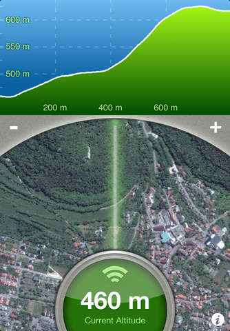
With this altimeter app you can determine the current elevation and analyze the terrain around you. Discover the height of hills in front of you or take a look at further away mountains.
FEATURES:
• High accuracy digital elevation model
• Range up to 800 meter (2500 ft)
• Calculation of altitudes in real time
• Precise elevation chart
• Display in meter or feet
The altitudes are calculated through online services, based on your GPS position and compass direction.
Whether biking, hiking or walking - with this altimeter app every trip is a journey of discovery!
Requirements
Your mobile device must have at least 1.92 MB of space to download and install Terrain Radar Altimeter For Short-Range app. Terrain Radar Altimeter For Short-Range was updated to a new version. Purchase this version for $0.00
If you have any problems with installation or in-app purchase, found bugs, questions, comments about this application, you can visit the official website of Nestele Engineering Joerg Nestele at http://terrainradar.com.
Copyright © Nestele Engineering, 2012