snowhow freeride


Detailed App Info:
Application Description
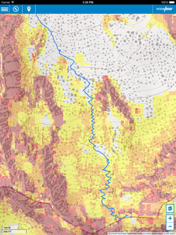
The SNOWHOW-Freeride App offers offline use of maps from Tyrol/Austria and Southtyrol/Italy. With an adjustable layer you can check the incline (steepness) of the slopes.
The slope incline is a key parameter for European decision making strategies in wintery and avalanche prone terrain.
The SNOWHOW-Freeride App is no substitute for any other tools of orientation and decision making and necessary safety gear. Shown tracks and map information are not recommendations for any terrain use.
Track recording:
The GPS-function of your phone allows you to find your current position on the map and also records your track on the mountain.
Combined with the color coding of the slope incline, you can evaluate the terrain around you.
Save tracks:
You can save your tracks on the phone and view them later. Once saved, you can synchronize your snowhow.info web-account with your phone (uploading your own tracks and downloading public available tracks).
Public tracks:
You can make your tracks public. Every other user of snowhow will be able to use your tracks on the mountain.
The more tracks we all publish, the more information we all get.
Color coding for incline:
The color coding shows the steepness of the terrain in four sectors.
These sectors are used in decision making strategies in Europe. The knowledge and correct use of decision making strategies (see http://goo.gl/y5Rmx ) is essential to be able to use the SNOWHOW-Freeride App properly. If you are not familiar with any kind of decision making strategies or any other knowledge about decision making in avanlanche prone terrain, do not use the SNOWHOW-Freeride App.
Opacity for color coding:
You can adjust how strong the colors for the steepness should appear on your screen. Click the “adjustments”-button and go to opacity. Any value from 0-100 changes the opacity.
Resolution and color coding:
Each color coded tile shows an area of 10 x 10 metres or real terrain. Keep in mind, that within 10 metres the steepness of a slope can change dramatically.
Compass:
If you want to adjust the map on your smartphone to reality, click on the compass-function. The screen will show you in which direction you should turn your phone to orientate it to North-South.
Weather data and Avalanche Bulletin:
If you go online with your smartphone, the SNOWHOW-Freeride App will automatically load the newest avalanche bulletin. The menu-feature shows you if your avalanche bulletin is up-dated (green button). If your avalanche bulletin is out of date, the button will be red.
This service is only available in Tyrol/Austria.
Once online, an extra layer shows you the weather stations of Tyrol/Austria. Clicking on any of them, you will be directed to web-based information of the specific weather station.
Continued use of GPS running in the background can dramatically decrease battery life.
Requirements
Your mobile device must have at least 7.77 MB of space to download and install snowhow freeride app. snowhow freeride was updated to a new version. Purchase this version for $0.00
If you have any problems with installation or in-app purchase, found bugs, questions, comments about this application, you can visit the official website of snowhow Verein zur Förderung von Bildung und Sport im alpinen Lebensraum at http://snowhow.info.
Copyright © 2013 snowhow.info