Nautical Charts - Belgium - for Marine Navigation


Detailed App Info:
Application Description
GPS Marine Charts App offers access to RNC charts covering Belgium waters (derived from Vlaamse Hydrografie data) with POI layers created from ENC charts. Only marine GPS app to have route assistance with Voice Prompts for marine navigation. It has route manager to create new boating routes or import existing GPX/KML routes. It supports Nautical Charts course up orientation.
Please visit http://www.gpsnauticalcharts.com/main/be/all-all-belgium-charts-nautical-charts-folio.html for complete list. If you don't find the chart for Belgium, please contact us at support at gpsnauticalcharts.com.
* Voice Prompts for marine navigation (requires GPS )
-prompts when approaching a boating route marker
-Continous distance and ETA updates
-Alerts when sailing/boating off route
-Alerts when boating in wrong direction
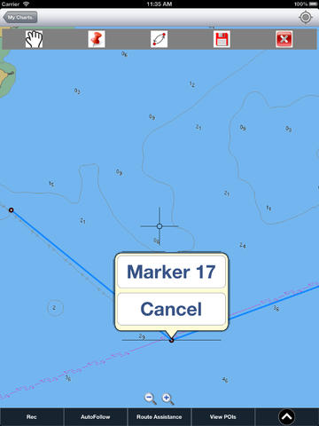
*Route Editing/Creation
-Create routes from scratch
-Edit existing GPX/KML routes.
-Add custom description to any route point.
-Drop markers along route.
* Offline charts derived from VH (Vlaamse Hydrografie) data.
-Visually draw area to download
-Textual search
-Catalog
-Charts reprojected for WGS84 datum
*Seamless chart quilting of marine charts
*Distance Bearing tool
*Create custom way points
- Using GPS
-Select point on map
-Manually enter latitude & longitude coordinates
*POI layer for marine charts
- Overlay POIs
- POI list derived from the equivalent ENC and contains all categories including Buoy, Light, Harbour facility, Wrecks, Obstr,.
*Search POIs/Way points
*Pan/Zoom/My Location
* Record Marine GPS tracks
* View tracks overlay
* Live track animation
* Track analytics/stats
* Export GPX tracks.
-Export to SDCard
-Share GPX tracks with friends.
* Auto Follow Mode (Course up)
-Continuously updates boat's location on chart
- Adjustable update frequency
Sample Nautical Charts (please visit http://www.gpsnauticalcharts.com/ for complete list)
A Baalhoek to Antwerp
A Nieuwpoort
A Oostende
A Vlissingen
B Antwerp to Hoboken
B Nieuwpoort
B Oostende
B Zeebrugge
C Brugge
C Hoboken to Wintam
C Zeebrugge
D Blankenberge
Dover and Calais to Orford Ness and Scheveningen
Dover Strait Eastern Part
Dover Strait to Westerschelde
Dunkerque and Approaches
Dunkerque to Oostende
Dunkerque to Vlissingen
Westerschelde Oostende to Westkapelle
West Hinder and Outer Gabbard to Vlissingen and Scheveningen
Albertkanaal
Antwerpen Haven
Beneden-Nete
Beneden Zeeschelde
Bocholt-Herentals
Boven-Schelde
Dessel-Kwaadmechelen
Dijle
Estuaire Vaart van Zeebrugge tot aan de Nederlandse Grens
Gent-Terneuzen
Kanaal naar Charleroi
Leie
Moervaart
Netekanaal
Oostende Haven met de 5-mijlszone Estuaire Vaart
Oostende Plassendalekanaal
Ringvaart om Gent
Rupel
Schelde-Rijnverbinding
van Zeebrugge Achterhaven-inclusief het Boudewijnkanaal-tot en met haven Brugge
Vlaanderen
Zeekanaal
Zeeschelde
Zuid-Willemsvaart
PLEASE NOTE: Continued use of GPS running in the background can dramatically decrease battery life.
Please visit http://www.gpsnauticalcharts.com/main/be/all-all-belgium-charts-nautical-charts-folio.html for complete list. If you don't find the chart for Belgium, please contact us at support at gpsnauticalcharts.com.
* Voice Prompts for marine navigation (requires GPS )
-prompts when approaching a boating route marker
-Continous distance and ETA updates
-Alerts when sailing/boating off route
-Alerts when boating in wrong direction
*Route Editing/Creation
-Create routes from scratch
-Edit existing GPX/KML routes.
-Add custom description to any route point.
-Drop markers along route.
* Offline charts derived from VH (Vlaamse Hydrografie) data.
-Visually draw area to download
-Textual search
-Catalog
-Charts reprojected for WGS84 datum
*Seamless chart quilting of marine charts
*Distance Bearing tool
*Create custom way points
- Using GPS
-Select point on map
-Manually enter latitude & longitude coordinates
*POI layer for marine charts
- Overlay POIs
- POI list derived from the equivalent ENC and contains all categories including Buoy, Light, Harbour facility, Wrecks, Obstr,.
*Search POIs/Way points
*Pan/Zoom/My Location
* Record Marine GPS tracks
* View tracks overlay
* Live track animation
* Track analytics/stats
* Export GPX tracks.
-Export to SDCard
-Share GPX tracks with friends.
* Auto Follow Mode (Course up)
-Continuously updates boat's location on chart
- Adjustable update frequency
Sample Nautical Charts (please visit http://www.gpsnauticalcharts.com/ for complete list)
A Baalhoek to Antwerp
A Nieuwpoort
A Oostende
A Vlissingen
B Antwerp to Hoboken
B Nieuwpoort
B Oostende
B Zeebrugge
C Brugge
C Hoboken to Wintam
C Zeebrugge
D Blankenberge
Dover and Calais to Orford Ness and Scheveningen
Dover Strait Eastern Part
Dover Strait to Westerschelde
Dunkerque and Approaches
Dunkerque to Oostende
Dunkerque to Vlissingen
Westerschelde Oostende to Westkapelle
West Hinder and Outer Gabbard to Vlissingen and Scheveningen
Albertkanaal
Antwerpen Haven
Beneden-Nete
Beneden Zeeschelde
Bocholt-Herentals
Boven-Schelde
Dessel-Kwaadmechelen
Dijle
Estuaire Vaart van Zeebrugge tot aan de Nederlandse Grens
Gent-Terneuzen
Kanaal naar Charleroi
Leie
Moervaart
Netekanaal
Oostende Haven met de 5-mijlszone Estuaire Vaart
Oostende Plassendalekanaal
Ringvaart om Gent
Rupel
Schelde-Rijnverbinding
van Zeebrugge Achterhaven-inclusief het Boudewijnkanaal-tot en met haven Brugge
Vlaanderen
Zeekanaal
Zeeschelde
Zuid-Willemsvaart
PLEASE NOTE: Continued use of GPS running in the background can dramatically decrease battery life.
Requirements
Your mobile device must have at least 13.94 MB of space to download and install Nautical Charts - Belgium - for Marine Navigation app. Nautical Charts - Belgium - for Marine Navigation was updated to a new version. Purchase this version for $24.99
If you have any problems with installation or in-app purchase, found bugs, questions, comments about this application, you can visit the official website of Bist LLC at http://gpsnauticalcharts.com/.
Copyright © 2013 Bist LLC