McDowell Mountain Road and Trail Map

Detailed App Info:
Application Description
"Best digital road and trail map of McDowell Mountain."
Our cartographers design maps that look wonderful on your iPhone, iTouch and iPad.
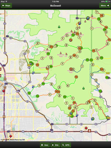
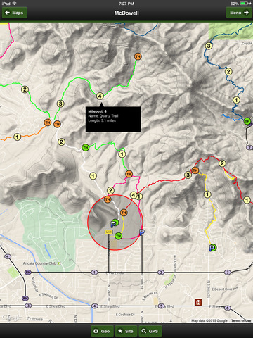
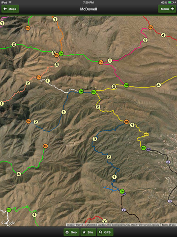
Hiking trails, highways and roads include distance markers and path lighting.
This version includes 400 meter semi-transparent elevation bands. These help you determine the difficulty level of hiking trails.
The map includes all of the parking lots, gates, peaks, scenic views and hotels in and around the park.
Enable the GPS to see your progress along roads and trails. The app shows the latitude, longitude and elevation for your position.
When you visit the area, you will hear these questions...
- How many miles is Sunrise Trail?
- How far of hike is it to Thompson Peak?
- How close can I park to Quartz trail head?
- How many miles did we hike today?
- How far is park from the Marriott?
- How long is Gateway Loop Trail?
Great questions and now using McDowell Mountain Road and Trail Map from Natural Resources GIS you can answer them quickly and easily.
Our cartographers design maps that look wonderful on your iPhone, iTouch and iPad.
Hiking trails, highways and roads include distance markers and path lighting.
This version includes 400 meter semi-transparent elevation bands. These help you determine the difficulty level of hiking trails.
The map includes all of the parking lots, gates, peaks, scenic views and hotels in and around the park.
Enable the GPS to see your progress along roads and trails. The app shows the latitude, longitude and elevation for your position.
When you visit the area, you will hear these questions...
- How many miles is Sunrise Trail?
- How far of hike is it to Thompson Peak?
- How close can I park to Quartz trail head?
- How many miles did we hike today?
- How far is park from the Marriott?
- How long is Gateway Loop Trail?
Great questions and now using McDowell Mountain Road and Trail Map from Natural Resources GIS you can answer them quickly and easily.
Requirements
Your mobile device must have at least 14.09 MB of space to download and install McDowell Mountain Road and Trail Map app. McDowell Mountain Road and Trail Map was updated to a new version. Purchase this version for $1.99
If you have any problems with installation or in-app purchase, found bugs, questions, comments about this application, you can visit the official website of John Buttery at http://www.naturalresourcesgis.com/emaps.html.
Copyright © Natural Resources GIS