KANSAI Route Map


Detailed App Info:
Application Description
●Application
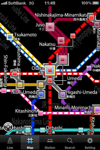
It is 'Kansai route map' that covers JR and the private railway in Kansai
Special express, fast, and "Station" of the rush etc. of not only the route map but also each route are understood.
JR and the private railway at Kansai 1,739 station are collected.
The area of the Kansai route map is a part Kansai 2 prefecture 5 prefecture (Osaka and Hyogo, Kyoto, Shiga, Nara, Wakayama, and Mie).
- JR West(JR Central Part is included.)
- Hankyu
- Hanshin
- Keihan
- Nankai
- Kintetsu
- Nose
- Osaka Monoral
- Kita-Osaka Kyuko
- Senboku
- Hankai
- Kobe New Transit
- Kobe Rapid
- Sanyo
- Shintetsu
- Hojo
- Chizu Kyuko
- Kitakinki Tang
- Keifuku
- Eizan
- Omi
- Shigaraki Kougen
- Sagano Sight-Seeing Tram
- Mizuma
- Wakayama
- Kishu
- Iga
- Ise
- Sangi
- Yoro
For a route map (a map), I cover all Osaka, Kyoto, metro lines of Kobe.
JR (2 companies): 37 route: 625 stations
Private railway (29 companies): 90 routes: 1,114 stations
●Feature
・Expansion reduced display of Kansai route map (original).
・Choice is possible from 30 railroad companies.
・Each route can be selected from the railway company further.
・Each route is a display of the station name (Japanese and English) and the transfers.
・In the station name list, the switch is possible in "Stop" by the station button.
・The station is displayed at the station by the train type (a limited express, high speed, a high speed express, an express, a semi-express, normal).
・I move to a route list when I tap a station name by a route map
・The subway (Osaka, Kyoto, and Kobe) also covers the route map.
・A list of station names indication function
(set screen)
・Any Japanese and English correspondence.
・The fixed display function of length and side is provided.
・TOP screens can be selected and either of Icon or List be selected.
・Osaka, Kyoto, and Kobe can select the map base.
●Language
Japanese/English
◎Related application program
- OSAKA Route Map (Osaka Prefecture)
- KYOTO Route Map (Kyoto Prefecture)
- HYOGO Route Map (Hyogo Prefecture)
Requirements
Your mobile device must have at least 40.17 MB of space to download and install KANSAI Route Map app. KANSAI Route Map was updated to a new version. Purchase this version for $0.99
If you have any problems with installation or in-app purchase, found bugs, questions, comments about this application, you can visit the official website of Northvillage NorthVillage Ltd. at http://photo-link.jp/.
Copyright © Northvillage
