Kananaskis Trail Map


Detailed App Info:
Application Description
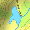
A topographical map of Kananaskis Country, Alberta, Canada.
The trails on the map include Burstall Pass, Chester Lake, Rawson Lake, Elbow Lake, Ptarmigan Cirque, Nihahi, Moose Mountain, and Ribbon Falls.
- Search or browse the names of trails, mountains, lakes, rivers, creeks, and backcountry campgrounds.
- Locate nearby mountains using the "Mountain Finder" (on devices with a camera and a compass).
- See the elevation for any point on the map.
- Track your current location with GPS (on devices with a GPS receiver).
- Add flags (waypoints) to mark locations.
- Jump to a location with a latitude/longitude coordinate.
- Measure the distance between two or more points on the map.
- Get driving directions to the current map location.
- Use the map with no Internet connection. The entire map is stored on your device.
This is an unofficial map and is not endorsed by the Government of Alberta.
Requirements
Your mobile device must have at least 32.01 MB of space to download and install Kananaskis Trail Map app. Kananaskis Trail Map was updated to a new version. Purchase this version for $0.00
If you have any problems with installation or in-app purchase, found bugs, questions, comments about this application, you can visit the official website of David Crawshay at http://sites.google.com/site/kananaskistrailmap/support.
Copyright © 2010 David Crawshay