iNautical


Detailed App Info:
Application Description
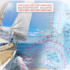
iNautical provides an electronic means to purchase and store incredibly high resolution (10 megapixel) maps of many fishing and boating destinations throughout the US. These are electronic versions of the same maps produced by WaterproofCharts.com and used by the United States Navy and Coast Guard.
Many of our charts combine multiple NOAA charts into one document along with fishing locations, boat ramps, restaurants, fueling stations, waypoints, and GPS coordinates...all the information you need to have a great day on the water.
To get you started, one complete map, "Florida to Puerto Rice & Mona Passage", is included for free with the reader program.
If you don't find the chart you're looking for, check back often. Our dedicated staff is digitizing more of our full library of charts every week!
Requirements
Your mobile device must have at least 20.02 MB of space to download and install iNautical app. iNautical is available on iTunes for $0.00
If you have any problems with installation or in-app purchase, found bugs, questions, comments about this application, you can visit the official website of Waterproof Charts LLC at http://inautical.waterproofcharts.com.
Copyright © Waterproof Charts, LLC