Hiking Central Adirondack Region


Detailed App Info:
Application Description
Get all the info for hiking 38 popular Adirondack Park trails, all in one app! Hiking Central Adirondack Region is your guide to hiking trails ranging from easy to challenging, campgrounds, area businesses and lots more in this comprehensive application. Click “...More” to learn why you should download this App today!
You’ve found the perfect trail to hike, thanks to your new Hiking Central Adirondack Region app. There’s no internet or cell phone connection out in the wild but that’s okay because you don’t need it. After simply opening the application, you find the trailhead information and everything else you need to know, including where you’re going to camp for the night. Gotta love this app!
Discover 38 wonderful trails to hike in the Adirondack Park. It doesn’t matter if you’re a beginner or a seasoned hiker looking for challenge, you’ll find some real hiking gems in this valuable resource. From the ever popular Bald Mountain in Old Forge, to Snowy Mountain near Indian Lake, there’s something for everyone, with a variety of terrain and scenic overlooks.
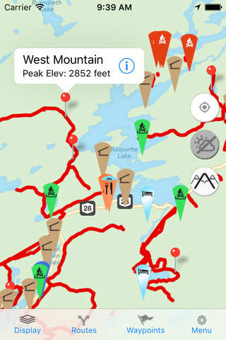
Once you’ve downloaded the app, you don’t need reception to access and use it. The included PDF documents hold all you want to know for each featured hike. You get trailhead info, length, difficulty level, elevation profile and a description of the experience. You’ll know exactly what you’re getting into before starting your hike. You can even view the accompanying maps in Street View, Satellite View, Hybrid View and USGS 1:24,000 Topographical View. Enable GPS and check your location relative to the trail.
Just tap a trail pin to check elevation change, miles and difficulty level. Look appealing? Then tap the arrow and view the PDF. This application is easy and comprehensive. Hiking Central Adirondack Region even gives you parking information, shows campground locations, lean-tos, outfitters, local businesses with phone numbers, shopping, museums, theaters and much more! Go hiking in the morning, visit the waterpark in the afternoon, dine out at night. You’ll know what’s in the area for you to enjoy while staying in the Adirondack region.
Have a look at some of the features you get in Hiking Central Adirondack Region:
* Attractive, easy-to-use interface
* Does not require a connection once downloaded
* With reception, can sync with website to get latest data
* Optional current GPS location display
* Includes comprehensive information for 38 hiking trails in the Adirondack Park
* Shows locations of DEC campgrounds and lean-tos
* Selection of map views
* Includes detailed PDF documents with everything you need to know
* Includes information about local businesses and attractions
* App is a mobile version of http://www.nyrecwebmap.com/
Download Hiking Central Adirondack Region right now, so you can plan your next adventure, from start to finish, before you even leave home.
Disclaimer: Please note that the trails in this app have come from the NYS DEC and from the towns in the Central Adirondack region. The majority of these trails have not been GPSed and are representations of the exact trail locations. Do not precisely navigate by following these trail representations. MVGIS cannot guarantee the accuracy of the trail locations nor can MVGIS assume responsibility for the condition of the trails depicted in the app. Please use caution and common sense at all times when hiking.
You’ve found the perfect trail to hike, thanks to your new Hiking Central Adirondack Region app. There’s no internet or cell phone connection out in the wild but that’s okay because you don’t need it. After simply opening the application, you find the trailhead information and everything else you need to know, including where you’re going to camp for the night. Gotta love this app!
Discover 38 wonderful trails to hike in the Adirondack Park. It doesn’t matter if you’re a beginner or a seasoned hiker looking for challenge, you’ll find some real hiking gems in this valuable resource. From the ever popular Bald Mountain in Old Forge, to Snowy Mountain near Indian Lake, there’s something for everyone, with a variety of terrain and scenic overlooks.
Once you’ve downloaded the app, you don’t need reception to access and use it. The included PDF documents hold all you want to know for each featured hike. You get trailhead info, length, difficulty level, elevation profile and a description of the experience. You’ll know exactly what you’re getting into before starting your hike. You can even view the accompanying maps in Street View, Satellite View, Hybrid View and USGS 1:24,000 Topographical View. Enable GPS and check your location relative to the trail.
Just tap a trail pin to check elevation change, miles and difficulty level. Look appealing? Then tap the arrow and view the PDF. This application is easy and comprehensive. Hiking Central Adirondack Region even gives you parking information, shows campground locations, lean-tos, outfitters, local businesses with phone numbers, shopping, museums, theaters and much more! Go hiking in the morning, visit the waterpark in the afternoon, dine out at night. You’ll know what’s in the area for you to enjoy while staying in the Adirondack region.
Have a look at some of the features you get in Hiking Central Adirondack Region:
* Attractive, easy-to-use interface
* Does not require a connection once downloaded
* With reception, can sync with website to get latest data
* Optional current GPS location display
* Includes comprehensive information for 38 hiking trails in the Adirondack Park
* Shows locations of DEC campgrounds and lean-tos
* Selection of map views
* Includes detailed PDF documents with everything you need to know
* Includes information about local businesses and attractions
* App is a mobile version of http://www.nyrecwebmap.com/
Download Hiking Central Adirondack Region right now, so you can plan your next adventure, from start to finish, before you even leave home.
Disclaimer: Please note that the trails in this app have come from the NYS DEC and from the towns in the Central Adirondack region. The majority of these trails have not been GPSed and are representations of the exact trail locations. Do not precisely navigate by following these trail representations. MVGIS cannot guarantee the accuracy of the trail locations nor can MVGIS assume responsibility for the condition of the trails depicted in the app. Please use caution and common sense at all times when hiking.
Requirements
Your mobile device must have at least 48.82 MB of space to download and install Hiking Central Adirondack Region app. Hiking Central Adirondack Region was updated to a new version. Purchase this version for $7.99
If you have any problems with installation or in-app purchase, found bugs, questions, comments about this application, you can visit the official website of Linda Rockwood at http://www.nyrecwebmap.com/hiking.htm.
Copyright © 2011 Mohawk Valley GIS