Equator Maps: Rocky Mountain National Park 2012

Detailed App Info:
Application Description
**INTRODUCTORY SALE OF $0.99 FOR A LIMITED TIME ONLY**
Equator Maps has developed a content rich outdoor recreation app to help outdoor enthusiasts explore Rocky Mountain National Park. The app contains several layers of map detail surrounded by a series of easy-to-use navigational tools and personal customization features to help make your outdoor experience more enjoyable and memorable.
Dedicated in 1915, Rocky Mountain National Park encompasses over 416 square miles with over 60 mountains exceeding 12,000 feet. Planning a hike in Rocky Mountains National Park? Looking for an app to help you navigate the trails? Worried you will not have Wi-Fi access while out on the trail? Then this is the app for you as we have included everything you will need in the download!
Key Content Features:
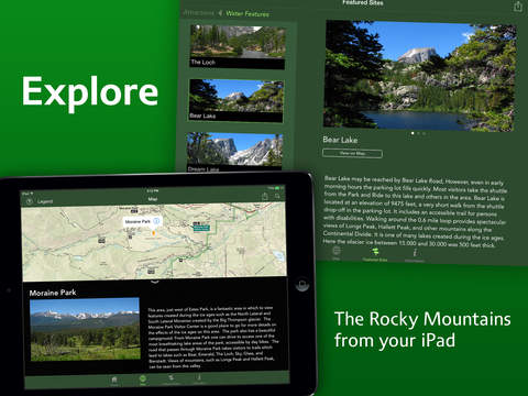
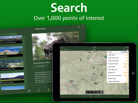
+ Full content and detail for Rocky Mountains National Park, covering Longs Peak, Lake Granby, Shadow Mountain, Trail Ridge, Moraine Park, East side of the Never Summer Range, Mummy Range, and more! Point of Interest listings for over 1000 locations in and around Rocky Mountains National Park.
+ Point of Interest listings for over 1000 locations in and around the Rocky Mountain National Park area.
Key Features Include:
+ GPS tracking of your location, even without Wi-Fi or cell reception
+ A revolutionary new trail navigation system
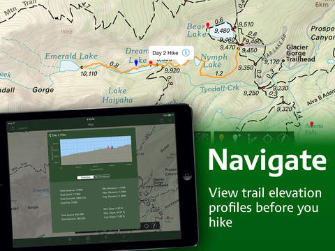
+ Dynamically generated trail elevation profiles
+ Map tools including distance, area, bearing and compass
+ Customized pins to record photos, comments, & Locations along your hike
+ Share your custom markers with others who have the app
+ Customize your markers to change their appearance
+ Detailed search capabilities by nearby locations and by type
+ Identify the Latitude/Longitude or UTM Coordinate for any place on the map
Equator Maps: Rocky Mountain National Park was developed by International Mapping. To learn more visit: www.internationalmapping.com
Equator Maps has developed a content rich outdoor recreation app to help outdoor enthusiasts explore Rocky Mountain National Park. The app contains several layers of map detail surrounded by a series of easy-to-use navigational tools and personal customization features to help make your outdoor experience more enjoyable and memorable.
Dedicated in 1915, Rocky Mountain National Park encompasses over 416 square miles with over 60 mountains exceeding 12,000 feet. Planning a hike in Rocky Mountains National Park? Looking for an app to help you navigate the trails? Worried you will not have Wi-Fi access while out on the trail? Then this is the app for you as we have included everything you will need in the download!
Key Content Features:
+ Full content and detail for Rocky Mountains National Park, covering Longs Peak, Lake Granby, Shadow Mountain, Trail Ridge, Moraine Park, East side of the Never Summer Range, Mummy Range, and more! Point of Interest listings for over 1000 locations in and around Rocky Mountains National Park.
+ Point of Interest listings for over 1000 locations in and around the Rocky Mountain National Park area.
Key Features Include:
+ GPS tracking of your location, even without Wi-Fi or cell reception
+ A revolutionary new trail navigation system
+ Dynamically generated trail elevation profiles
+ Map tools including distance, area, bearing and compass
+ Customized pins to record photos, comments, & Locations along your hike
+ Share your custom markers with others who have the app
+ Customize your markers to change their appearance
+ Detailed search capabilities by nearby locations and by type
+ Identify the Latitude/Longitude or UTM Coordinate for any place on the map
Equator Maps: Rocky Mountain National Park was developed by International Mapping. To learn more visit: www.internationalmapping.com
Requirements
Your mobile device must have at least 203.42 MB of space to download and install Equator Maps: Rocky Mountain National Park 2012 app. Equator Maps: Rocky Mountain National Park 2012 was updated to a new version. Purchase this version for $0.99
If you have any problems with installation or in-app purchase, found bugs, questions, comments about this application, you can visit the official website of International Mapping at http://internationalmapping.com/equator-maps-rocky-mountain-national-park.
Copyright © 2012 Equator Maps / International Mapping