Buller-Howitt Outdoor Recreation Guide


Detailed App Info:
Application Description
Take Spatial Vision’s award-winning SVmaps with you on your iPhone with the latest ORG map of the Buller-Howitt Alpine Area.
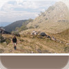
The Buller ORG app contains rich base mapping of the area linked with comprehensive guide information about recreation features. The app provides all the guide detail of the print map plus information about every recreation site in the area. Reveal the extraordinary history of the area as you navigate through the region by foot or car, find the best place to camp or have a picnic, even store your favourite walks.
Guide includes:
-introduction
-colour-coded walks, including overnight walks, day walks and favourites (with distance, time, walk rating and warnings)
-history of the area
-safety information
-activities
-vivid photography
-further information
-web sites and phone numbers
Detailed topographic map with recreation sites, points of interest, dynamic scale bar, heading, location in latitude and longitude as well as Map Grid of Australia, a detailed legend, usage instructions and app settings.
Requirements
Your mobile device must have at least 97.08 MB of space to download and install Buller-Howitt Outdoor Recreation Guide app. Buller-Howitt Outdoor Recreation Guide was updated to a new version. Purchase this version for $8.99
If you have any problems with installation or in-app purchase, found bugs, questions, comments about this application, you can visit the official website of Spatial Vision at http://www.svmaps.com.au.
Copyright © Spatial Vision Innovations Pty Ltd