Aqua Map Germany HD - Marine GPS Offline Charts


Detailed App Info:
Application Description
One World ~ One Globe ~ One Map!
Download all official BSH (Bundesamt für Seeschiffahrt und Hydrographie) chart data for your area, downloads in seconds, in minimal storage space on your mobile device. No internet connection needed after download. The first marine viewer using the full power of the Retina display, intuitive symbols with realistic and clear colors. All marine map/chart information is included.
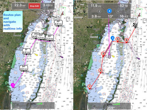
Zoom, pan and see your current position on the map with the maximum detail of the official vector charts. All buoys, rocks, symbols, depths, obstructions, coastlines it’s in Aqua Map.
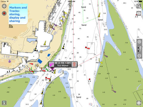
Store and display your tracks and favorite places (marker points).
CURRENT COVERAGE
- Complete marine coverage of the Bundesamt für Seeschiffahrt und Hydrographie.
and the following inland main rivers:
Berlin-Spandauer-Schifffahrtskanal (From/to Km 1 12)
Donau (From/to Km 2200 2410)
Dortmund-Ems-Kanal (From/to Km 0 10)
Elbe (From/to Km 5 605)
Elbe-Havel-Kanal (From/to Km 330 379)
Elbe-Seitenkanal (From/to Km 0 110)
Havel-Oder-Wasserstraße (From/to Km 5 133)
Main (From/to Km 0 380)
Main-Donau-Kanal (From/to Km 0 170)
Mittellandkanal (From/to Km 0 290)
Mosel (From/to Km 0 240)
Neckar (From/to Km 0 200)
Rhein (From/to Km 330 860)
Rhein-Herne-Kanal (From/to Km 1 4)
Ruhr (From/to Km 0 12)
Saar (From/to Km 0 90)
Spree-Oder-Wasserstraße (From/to Km 1 18)
Untere Havel-Wasserstraße (Spandau - Plaue) (From/to Km 3 65)
Wesel-Datteln-Kanal (From/to Km 0 5)
Weser (From/to Km 210 360)
Westoder (From/to Km 907 907)
Important:
"Continued use of GPS running in the background can dramatically decrease battery life."
Check our website to get more details:
www.globalaquamaps.com
Download all official BSH (Bundesamt für Seeschiffahrt und Hydrographie) chart data for your area, downloads in seconds, in minimal storage space on your mobile device. No internet connection needed after download. The first marine viewer using the full power of the Retina display, intuitive symbols with realistic and clear colors. All marine map/chart information is included.
Zoom, pan and see your current position on the map with the maximum detail of the official vector charts. All buoys, rocks, symbols, depths, obstructions, coastlines it’s in Aqua Map.
Store and display your tracks and favorite places (marker points).
CURRENT COVERAGE
- Complete marine coverage of the Bundesamt für Seeschiffahrt und Hydrographie.
and the following inland main rivers:
Berlin-Spandauer-Schifffahrtskanal (From/to Km 1 12)
Donau (From/to Km 2200 2410)
Dortmund-Ems-Kanal (From/to Km 0 10)
Elbe (From/to Km 5 605)
Elbe-Havel-Kanal (From/to Km 330 379)
Elbe-Seitenkanal (From/to Km 0 110)
Havel-Oder-Wasserstraße (From/to Km 5 133)
Main (From/to Km 0 380)
Main-Donau-Kanal (From/to Km 0 170)
Mittellandkanal (From/to Km 0 290)
Mosel (From/to Km 0 240)
Neckar (From/to Km 0 200)
Rhein (From/to Km 330 860)
Rhein-Herne-Kanal (From/to Km 1 4)
Ruhr (From/to Km 0 12)
Saar (From/to Km 0 90)
Spree-Oder-Wasserstraße (From/to Km 1 18)
Untere Havel-Wasserstraße (Spandau - Plaue) (From/to Km 3 65)
Wesel-Datteln-Kanal (From/to Km 0 5)
Weser (From/to Km 210 360)
Westoder (From/to Km 907 907)
Important:
"Continued use of GPS running in the background can dramatically decrease battery life."
Check our website to get more details:
www.globalaquamaps.com
Requirements
Your mobile device must have at least 68.4 MB of space to download and install Aqua Map Germany HD - Marine GPS Offline Charts app. Aqua Map Germany HD - Marine GPS Offline Charts is available on iTunes for $10.99
If you have any problems with installation or in-app purchase, found bugs, questions, comments about this application, you can visit the official website of Giorgio Ghiggini at http://www.globalaquamaps.com.
Copyright © 2013, GEC di Giorgio Ghiggini