VT Trails


Detailed App Info:
Application Description
VT Trails was built with all Vermont hikers in mind. Boasting statewide USGS topographic maps, over 2,000 digitized hiking and walking trails and a high accuracy track of Vermont's Long Trail accompanied by more than 600 points of interest gathered by through hikers, this app is built to take you to and from the most scenic vistas in Vermont with style and confidence. App Features:
Statewide:
-USGS topographic maps stored on your phone. No cell coverage needed!
-Over 2,000 hiking and walking trails.
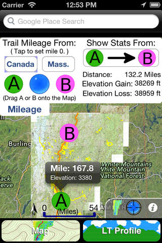
-A mileage calculator for trip planning.
-Place search powered by Google.
Long Trail Focused:
-A highly detailed track of Vermont's longest hiking trail.
-Detailed USGS topographic maps (1:24,000 scale) flanking the trail.
-A trail mileage and elevation calculator.
-Shelters, official and unofficial, with descriptive photos.
-An interactive profile view showing elevation, trail intersections and points of interest.
-100+ water sources categorized as rivers, streams and ponds.
-Hundreds more waypoints including: tent sights, views, fire pits, parking, summits, towers and gaps.
Detailed USGS topographic maps are stored on your phone, so go ahead and turn on airplane mode to extend battery life and boot up the GPS only when you need it to pinpoint your location.
The mileage menu does all the math for you. Just drag and drop waypoints onto the map or profile and trail miles, straight line distances and elevation gain/loss are calculated for you instantly.
A selection of over 50 major side trails accessing the LT can be added to the map with the flick of a switch, guiding you with ease to the most scenic locations in Vermont.
An interactive profile view of the LT shows you trail mileage and elevation so you can track you progress up VT's highest peaks.
Any stream near the LT and big enough to wedge the mouth of your water bottle into has been marked.
65 shelters, ski lodges and shacks have been included with descriptive photos.
Statewide:
-USGS topographic maps stored on your phone. No cell coverage needed!
-Over 2,000 hiking and walking trails.
-A mileage calculator for trip planning.
-Place search powered by Google.
Long Trail Focused:
-A highly detailed track of Vermont's longest hiking trail.
-Detailed USGS topographic maps (1:24,000 scale) flanking the trail.
-A trail mileage and elevation calculator.
-Shelters, official and unofficial, with descriptive photos.
-An interactive profile view showing elevation, trail intersections and points of interest.
-100+ water sources categorized as rivers, streams and ponds.
-Hundreds more waypoints including: tent sights, views, fire pits, parking, summits, towers and gaps.
Detailed USGS topographic maps are stored on your phone, so go ahead and turn on airplane mode to extend battery life and boot up the GPS only when you need it to pinpoint your location.
The mileage menu does all the math for you. Just drag and drop waypoints onto the map or profile and trail miles, straight line distances and elevation gain/loss are calculated for you instantly.
A selection of over 50 major side trails accessing the LT can be added to the map with the flick of a switch, guiding you with ease to the most scenic locations in Vermont.
An interactive profile view of the LT shows you trail mileage and elevation so you can track you progress up VT's highest peaks.
Any stream near the LT and big enough to wedge the mouth of your water bottle into has been marked.
65 shelters, ski lodges and shacks have been included with descriptive photos.
Requirements
Your mobile device must have at least 77.64 MB of space to download and install VT Trails app. VT Trails was updated to a new version. Purchase this version for $2.99
If you have any problems with installation or in-app purchase, found bugs, questions, comments about this application, you can visit the official website of Walk About Apps Tyler Elko at http://btunes.herokuapp.com.
Copyright © Tyler Elko