OS MapFinder

Detailed App Info:
Application Description
UPDATE: MAP TILE PRICES REDUCED FOR A LIMITED PERIOD, DOWNLOAD TODAY TO TAKE FULL ADVANTAGE.
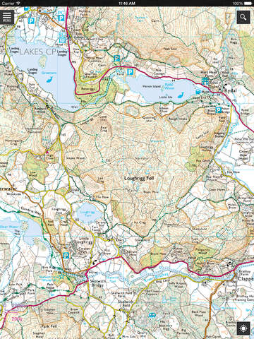
OS MapFinder is the first official iPhone/iPad/iPod Touch App from Ordnance Survey, enabling users to view, navigate and download the most up-to-date OS Landranger (1:50 000) and OS Explorer (1:25 000) maps of Great Britain in amazing high-resolution.
OS MapFinder is ideal for walkers, ramblers, runners, cyclists and generally anyone looking to enjoy the outdoors. The fast and easy to use App comes bundled with free overview mapping - including Ordnance Survey’s trusted and reliable 1:250 000 Scale mapping. The App allows users to quickly, and accurately, search by place name, postcode, and grid reference.
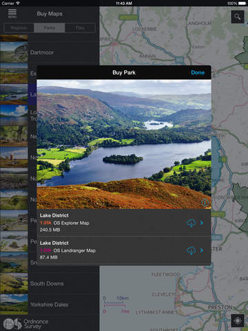
Ordnance Survey maintains Great Britain’s definitive digital mapping database, and with OS MapFinder users can enjoy the print quality of the trusted OS Landranger and OS Explorer maps (660dpi) on their iOS devices. The App allows users to buy and create their own bespoke high-resolution maps via Apple’s ‘In App Purchase’ service. Each mapping tile is fully downloaded to the iOS device, meaning that it will work anywhere regardless of iPhone/iPad signal. The tile download facility allows users to select and purchase up-to-date mapping of their favourite locations, and then easily plan, plot, record and review their own bespoke walks, runs and cycle rides.
OS MapFinder brings all the detail and reliability of the iconic Ordnance Survey paper maps to iOS devices.
OS MapFinder features Include:
•Download and purchase trusted and up-to-date OS Explorer and OS Landranger maps in amazing high-resolution detail
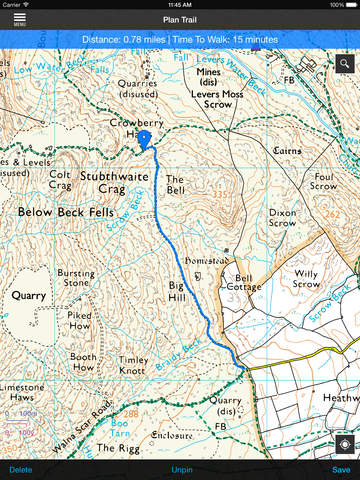
• Route recording – record your own personal routes in real time
•View current time, distance, speed , Ordnance Survey grid reference, latitude and longitude
•Route planning and track functionality – plan your own bespoke routes and measure your times for each trip
•Review and plan new routes from your own personal routes library
•Select your own route types , walking , running or cycling and view the estimated route duration
•Smooth and fast zooming and scrolling between maps
•Real-time location tracking via GPS or Wifi positioning
•Ordnance Survey free map stack viewable offline
•A free OS Landranger and OS Explorer map tile of Exeter
•Offline viewing – all downloaded OS Landranger and OS Explorer map tiles can be viewed offline
•Place name lookup – search for thousands of places across Great Britain in seconds
•Postcode lookup – search and locate postcodes
•Grid reference lookup
•Useful tips on how to read and navigate maps.
UPDATE:
Any 100 km2 map tiles purchased will be updated for FREE under a revision program. Tile updates are unlimited for the life of the application*.
Map tiles once purchased through your iTunes account can be uploaded onto all devices registered to that account (i.e. if you purchase on iPhone you do not have to repurchase on iPad). To do this, simply go to "Purchase" from the menu and then tap the sync symbol (to the left of the search). You will need to enter your Apple id and the app will start syncing.
Users who are having difficulty in finding purchased maps should make sure they are zooming in far enough. We will include a lock scale function on a future release.
*or until 31st March 2016 (whichever is longer), updates will generally occur bi-annually as we update our mapping.
Continued use of GPS running in the background can dramatically decrease battery life..
OS MapFinder is the first official iPhone/iPad/iPod Touch App from Ordnance Survey, enabling users to view, navigate and download the most up-to-date OS Landranger (1:50 000) and OS Explorer (1:25 000) maps of Great Britain in amazing high-resolution.
OS MapFinder is ideal for walkers, ramblers, runners, cyclists and generally anyone looking to enjoy the outdoors. The fast and easy to use App comes bundled with free overview mapping - including Ordnance Survey’s trusted and reliable 1:250 000 Scale mapping. The App allows users to quickly, and accurately, search by place name, postcode, and grid reference.
Ordnance Survey maintains Great Britain’s definitive digital mapping database, and with OS MapFinder users can enjoy the print quality of the trusted OS Landranger and OS Explorer maps (660dpi) on their iOS devices. The App allows users to buy and create their own bespoke high-resolution maps via Apple’s ‘In App Purchase’ service. Each mapping tile is fully downloaded to the iOS device, meaning that it will work anywhere regardless of iPhone/iPad signal. The tile download facility allows users to select and purchase up-to-date mapping of their favourite locations, and then easily plan, plot, record and review their own bespoke walks, runs and cycle rides.
OS MapFinder brings all the detail and reliability of the iconic Ordnance Survey paper maps to iOS devices.
OS MapFinder features Include:
•Download and purchase trusted and up-to-date OS Explorer and OS Landranger maps in amazing high-resolution detail
• Route recording – record your own personal routes in real time
•View current time, distance, speed , Ordnance Survey grid reference, latitude and longitude
•Route planning and track functionality – plan your own bespoke routes and measure your times for each trip
•Review and plan new routes from your own personal routes library
•Select your own route types , walking , running or cycling and view the estimated route duration
•Smooth and fast zooming and scrolling between maps
•Real-time location tracking via GPS or Wifi positioning
•Ordnance Survey free map stack viewable offline
•A free OS Landranger and OS Explorer map tile of Exeter
•Offline viewing – all downloaded OS Landranger and OS Explorer map tiles can be viewed offline
•Place name lookup – search for thousands of places across Great Britain in seconds
•Postcode lookup – search and locate postcodes
•Grid reference lookup
•Useful tips on how to read and navigate maps.
UPDATE:
Any 100 km2 map tiles purchased will be updated for FREE under a revision program. Tile updates are unlimited for the life of the application*.
Map tiles once purchased through your iTunes account can be uploaded onto all devices registered to that account (i.e. if you purchase on iPhone you do not have to repurchase on iPad). To do this, simply go to "Purchase" from the menu and then tap the sync symbol (to the left of the search). You will need to enter your Apple id and the app will start syncing.
Users who are having difficulty in finding purchased maps should make sure they are zooming in far enough. We will include a lock scale function on a future release.
*or until 31st March 2016 (whichever is longer), updates will generally occur bi-annually as we update our mapping.
Continued use of GPS running in the background can dramatically decrease battery life..
Requirements
Your mobile device must have at least 342.11 MB of space to download and install OS MapFinder app. OS MapFinder was updated to a new version. Purchase this version for $0.00
If you have any problems with installation or in-app purchase, found bugs, questions, comments about this application, you can visit the official website of Ordnance Survey Limited at http://www.magazine.ordnancesurveyleisure.co.uk/magazine/tscontent/editorials/mapfinder/.
Copyright © Ordnance Survey Leisure